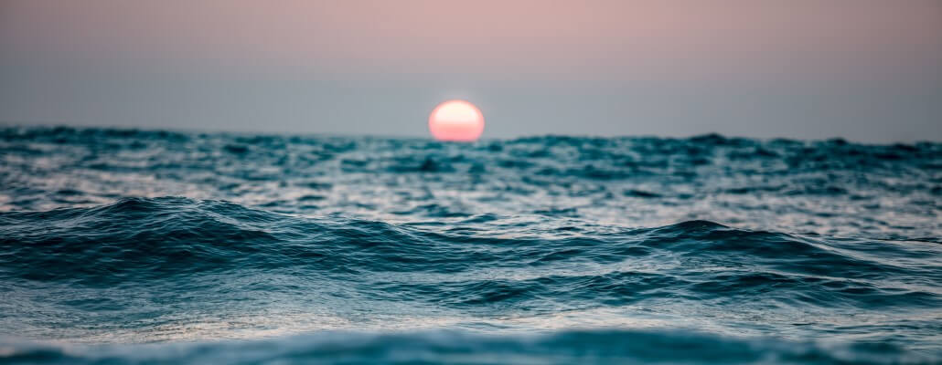
The world is home to five massive oceans, that account for around 96.5% of all of Earth’s water! Humans have explored only 5% of the world’s oceans, which makes you wonder what discoveries still await us.
The names of these oceans are: Pacific Ocean, Atlantic Ocean, Indian Ocean, Arctic Ocean, and the Southern Ocean. An acronym that can help remember these is P.A.I.A.S., in regards to their size from biggest to smallest!
Below are some fun and amazing facts about the oceans for kids.
Interesting Ocean Facts
1. The Pacific is the largest of all the oceans of the world.
It covers more than 30% of the Earth’s surface.
2. The word ‘Pacific’ comes from the Latin word ‘pacificus’ which means peaceful.
While the meaning of The Pacific Ocean would translate to calm and peaceful, in reality the pulsating waves stir up quite the furore!
3. The Pacific Ocean hosts a ring of fire.
Almost 75% of the Earth’s volcanoes form a ring around the Pacific basin, giving rise to a unique loop responsible for most of the world’s major earthquakes and volcanic eruptions.
4. Most of the islands of the world are found in the Pacific Ocean.
There are about 25,000 islands and Indonesia alone comprises 17,508 islands, while Japan consists of 3,000.
5. The lowest point on Earth is in the Pacific Ocean, called Challenger Deep.
It is located near Guam in the Philippine Sea at the end of the Mariana Trench. It has a depth of 10,920m or 35,827 feet.
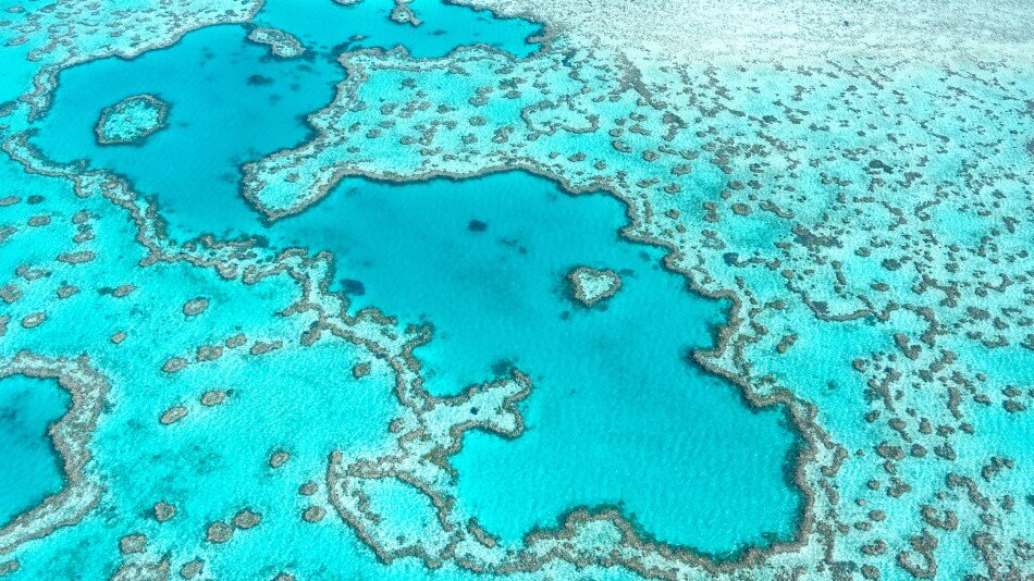
6. The Pacific Ocean has the largest coral reef called the Great Barrier Reef.
It’s located off the Australian Coast and is popular with tourists and divers.
7. The Atlantic Ocean is the second largest ocean in the world.
It can be found between the continents of American, Europe and Africa.
8. The Atlantic Ocean covers 20% of the Earth’s surface.
It is is half the size of the Pacific Ocean. It is known to be growing in size as it spreads along the Mid-Atlantic Coasts.
9. The Mid-Atlantic Ridge is the longest mountain range on Earth.
It spreads from Iceland to Antarctica beneath the Atlantic.
10. Aquatic animals such as the Thresher Shark are found in the waters of the Atlantic.
It’s also home to manatees, sea lions, catfish, starfish, penguins and more!
11. The Indian Ocean is located between Africa and Australasia.
It is the largest breeding ground in the world for humpback whales.
12. Coelacanth, a fish which was thought to be extinct, is said to have been discovered in the Indian Ocean.
It is found in the warm waters of the Comoro islands between Mozambique and Madagascar.
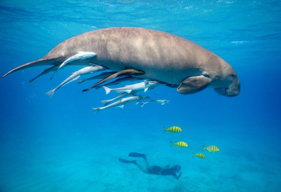
13. The Indian Ocean is home to many endangered sea species such as turtles, seals, and dugongs (also called sea cows).
Dugongs are cousins of manatees, but are marine animals as opposed to freshwater.
14. The Northern Indian Ocean is the transport route for oil as it connects oil-rich countries from the Middle East with Asia.
Cargo ships carrying 17 million barrels of crude oil are known to be transported from the Persian Gulf on its waters.
15. The Southern Ocean is located in the Southern Hemisphere off Antarctica around the South Pole across the Antarctic circle.
The Southern Ocean is also known as the Antarctic Ocean.
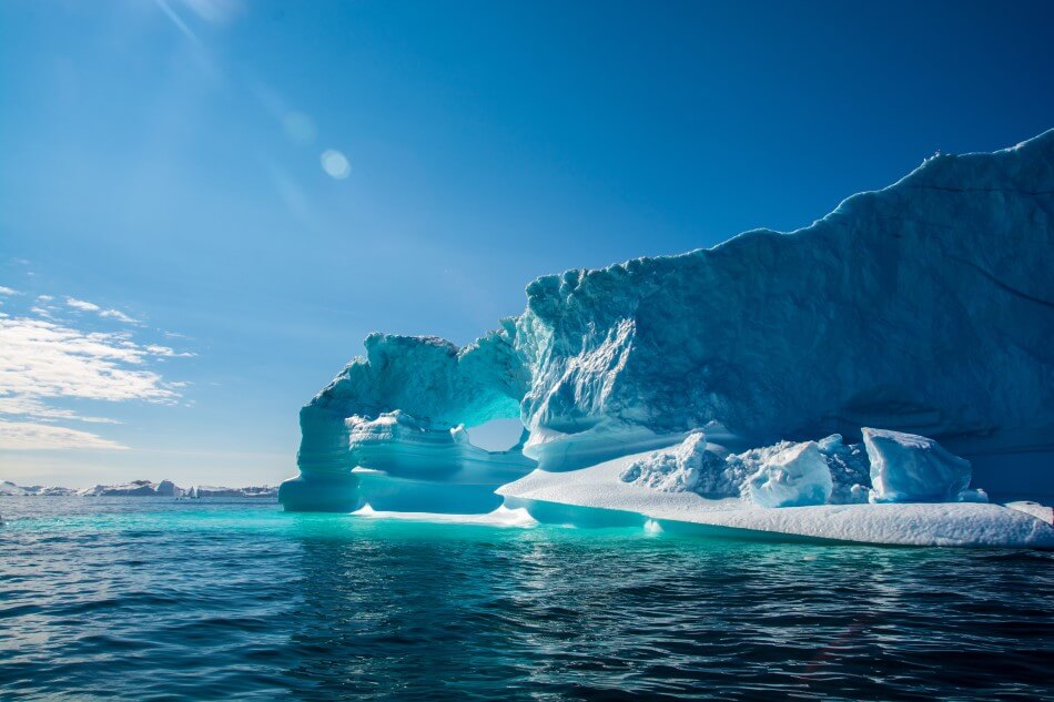
16. You can encounter icebergs in the Southern Ocean during any season.
The icebergs can measure several hundred feet high!
17. The water temperature in the Southern Ocean generally falls below 0 degrees Celsius / 32 Fahrenheit.
Despite this, more than 50,000 tourists still visit the Southern Ocean every year!
18. The Southern Ocean is home to Emperor Penguins and Wandering Albatrosses.
You’ll also find sharks, whales, eels, jellyfish, crabs and more.
19. In the Arctic Ocean’s waters can be found a jellyfish with the unique name of the ‘Lion’s Mane Jellyfish.’
It lives on plankton and fishes and grows up to 2.4m, or 8 feet across.
20. Some of the Arctic ground features are named after famous Arctic explorers.
Nansen Basin is named after Fridtjof Nansen, and Mendeleyev Ridge is named after Dmitri Mendeleyev.
21. On the Arctic Region’s islands, permafrost can be found.
Permafrost is essentially soil that is frozen for more than two years!
22. One of the biggest ports of the Arctic Ocean is the Churchill in Canada.
In Churchill, the number of polar bears outnumbers people during the summer.
23. The Arctic Region is home to the Northern Lights.
It’s a mesmerising tourist attraction, that can be observed in the sky between November and April.
Hopefully that’s enough bite-sized ocean facts to sink your teeth in to. Read on to learn more about oceans, their water, circulation, currents and more!
Ocean Water
The Earth’s oceans contain 332,519,000 cubic miles of water – or around 96% of all the water on the planet. This water is not uniform but varies in temperature, pressure, salinity, and illumination/darkness. These factors tend to change due to depth, dividing the oceans into different layers. However there are also differences between tropical, temperate, and polar latitudes and different seasons.
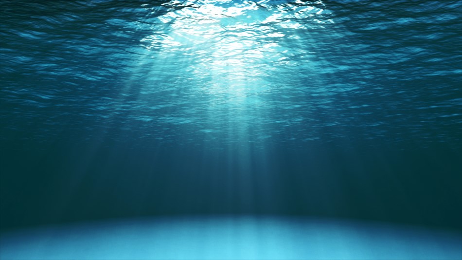
Different wavelengths of light penetrate water to different extents. Ocean water strongly absorbs longer wavelengths such as red, orange, and yellow, preventing these colors from penetrating more than a few meters. Only light in the blue area of the spectrum reaches beyond 50 meters resulting in everything at this depth appearing to be a blue-gray color. This is why the ocean is blue!
Below around 200 meters even blue light gets completely absorbed, making the ocean completely dark. Because phytoplankton, tiny organisms which form the basis of the ocean food chain, need light to grow, they are only found in the upper light-filled layers along with almost all other marine life. Animals that live in the darkness have evolved the ability to produce their own light through bioluminescence. Other creatures are able to gain energy from the bodies of creatures which sink to the ocean floor, or from hydrothermal vents which release chemicals and other nutrients.
Water Pressure
At the surface the atmospheric pressure on any object is around 14.7 pounds per square inch (a level known as 1 bar). Underwater, pressure increases at a rate of 1 bar per 10 meters increase in depth due to the fact that water is much denser than air. At the very deepest parts of the oceans the pressure is over 1,000 times that of the surface, or around 16,000 pounds per square inch (roughly the same as the entire weight of an elephant resting on an area the size of a postage stamp). Even at the average ocean depth the pressure is still over 400 times that of the surface. The deepest any human has travelled without protective equipment is just over 200 meters – a depth which crushes human lungs to around the size of a soda can. Animals which live at extreme pressures have special adaptations to their bodies.
Ocean Salinity (Saltiness!)
The average salinity of the oceans is around 35 grams of salt per liter (1,000 grams) of water. However the salinity of any particular area of water varies depending on a complex mixture of factors including rates of evaporation and precipitation and proximity to freshwater sources.
Areas of high salinity are usually away from the mouths of rivers which input fresh water. Sub-tropical regions as well as landlocked seas also have areas of high salinity due to their high rates of evaporation.
At high latitudes salinity is low due to lower evaporation rates and the melting of ice which dilutes seawater. Salinity is also lower in most areas along the equator due to high rates of rainfall which are greater than evaporation.
Ocean Water Temperature
Water temperature varies greatly depending on latitude, season, depth, and salinity. In tropical and subtropical regions, solar heating warms the upper ocean water to an average of around 77ºF (25 °Celsius).
From a depth of around 300 meters to about 1,000 meters (a region known as the thermocline) the temperature drops sharply to about 46ºF (7.7 °Celsius).
Below 1,000 meters the temperature decreases gradually to about 35ºF (1.6 °Celsius) in the deep ocean.
In mid latitudes the surface temperature of the water varies due to seasonal changes in the sun’s intensity from around 63ºF in summers to 50ºF in winters.
In high latitudes and polar oceans the surface temperatures average between 32 to 41ºF however in some places the water can drop below its freezing point (32ºF) creating large areas of frozen water.
Ocean Water Density
The temperature and salinity of water affects its density. As water warms, its molecules become more energetic and move further apart which reduces its density. As it cools, the molecules become less energetic and move closer together making it more dense. Water with a higher salinity is also more dense than water with a low salinity.
Of the two factors, temperature has a greater effect on the density of water than salinity. A layer of water with higher salinity can actually float on top of water with lower salinity if the layer with higher salinity is much warmer.
Changes in the density of water play a major role in regulating the Earth’s temperature and climate as layers of warm and cooler water form a conveyer belt which moves vast amounts of energy around the planet.
Ocean Circulation & Currents
The Earth’s water is in constant motion due to a large number of factors including :
- Tides – The moon, and to a much lesser extent the sun, have a gravitational impact on the Earth’s surface which results in a bulge of water on the side facing the moon. As the earth rotates and the moon orbits this attractive force alters causing different tide levels at different times of the month.
- Wind – Wind blowing across a large surface of water can create tiny ripples. Continued pressure can cause these ripples to grow and merge to form bigger and bigger waves, which can then travel across thousands of miles of open water before reaching land.
- Earth’s Rotation – The rotation of the Earth creates a force known as the Coriolis Effect. In the northern hemisphere this force deflects wind-driven surface movements slightly to the right, while in the southern hemisphere these movements are directed slightly to the left. Another force, known as Ekman Transport magnifies this effect making surface water move at almost a right-angle to the wind. These forces combined lead to the creation of large-scale circular movements of water called gyres which rotate clockwise in the northern hemisphere and counter-clockwise in the southern hemisphere. The currents on the eastern sides of oceans are generally weak, cold, and move towards the equator. Those on the western sides are strong, warm, and move away from the equator.
Local currents are created due to the interaction of tidal forces and the shapes of coastlines. These currents are particularly noticeable where large volumes of water pass through narrow channels between islands and up bays and estuaries. These tides vary in strength and direction due to the movement of the Earth and moon. In some places they can create natural phenomena such as tidal bores (where the leading edge of a tide creates a wave), and whirlpools (created when tides from two different directions converge).
Water not only moves horizontally but also vertically. The movement of water from the surface to deeper regions is known as downwelling while water which moves in the opposite direction is known as upwelling. One cause of this vertical movement is the heating and cooling of water combined with changes in levels of salinity. Wind patterns can also cause water masses to converge, forcing them both downwards, or to diverge. In both cases water must move to replace the converging or diverging water either from above or below. Deeper waters tend to be rich in nutrients due to the decomposition of creatures which have died and sunk down. Upwelling helps to bring these waters to the surface where they can help to support a wide range of life.
Deep water currents are formed due to the downwelling of cold, dense, salty water in polar and sub-polar regions. Once this water reaches a depth level of equal density it spreads out over huge distances. In other regions, less dense water rises closer to the surface where it gains heat from from water masses above it. The deep water currents move incredibly slowly, no more than a few meters per day, and it can take hundreds or even thousands of years for a sunken body of water to rise again to the surface. Despite its slow speed the, Global Conveyor Belt moves over 100 times more water than the world’s largest river each day. As this water moves around the globe it enriches nutrient-poor waters by carrying them through the nutrient-rich deeper layers. The belt also helps to regulate global temperatures.
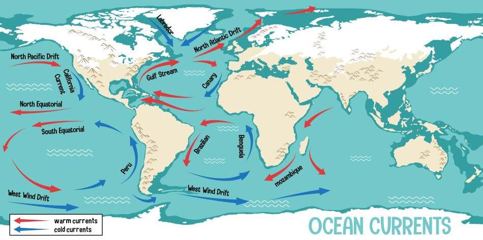
Major Ocean Currents
Warm Currents
- Alaskan Current – Flows north into the Gulf of Alaska.
- Agulhas Current – Flows south from the equator between the East African coast and Madagascar.
- Brazil Current – Flows south from the equator past the east coast of South America.
- East Australian Current – Flows south from the equator past the east coast of Australia.
- Gulf Stream – Flows north from the Caribbean past the east coast of North America.
- Kuroshio Current – Flows north from the equator past Japan.
- North Atlantic Drift – Flows across the Atlantic from North America to Europe.
- North Equatorial – Flows along the northern side of the equator from east to west.
- North Pacific – Flows eastwards across the pacific to Alaska
- Norwegian Current – Flows northeast past Norway into the Arctic ocean.
- Somali Current – Flows north from the equator past east Africa towards Arabia.
- South Equatorial – Flows along the southern side of the equator from east to west.
Cold Currents
- Alaskan Current – Flows south from the Gulf of Alaska.
- Benguela Current – Flows north from the South Atlantic past the west coast of Africa.
- California Current – Flows south from Alaska past the west coast of North America.
- Canary Current – Flows south from the North Atlantic past the coast of Spain and North Africa.
- East Greenland Current – Flows around the southeast and southwest coasts of Greenland.
- East Wind Drift – Flows east to west along the coast of Antarctica.
- Labrador Current – Flows south from the Arctic past the east coast of Canada.
- Oyashio Current – Flows south from the Bearing Strait past the east coast of Japan.
- Peru Current – Flows north from the south Pacific past the west coast of South America.
- West Wind Drift – Flows west to east across the southern Pacific, Atlantic, and Indian oceans.
Ocean Tectonics
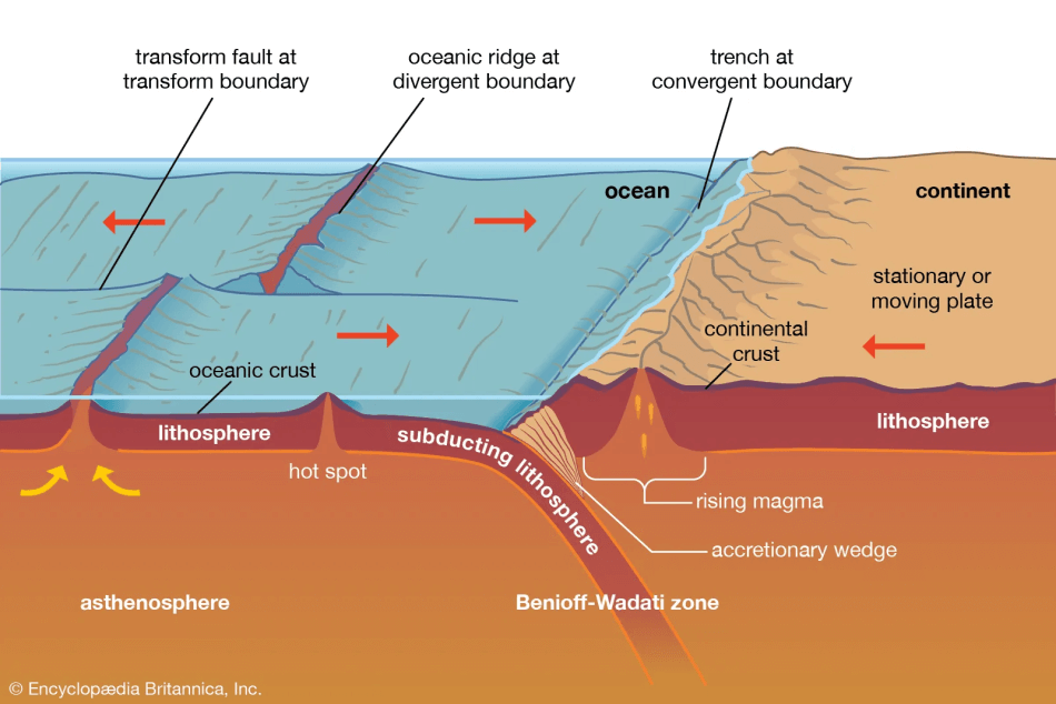
Because of the movement of Earth’s tectonic plates no part of the seafloor is greater than 200 million years old. A combination of volcanic and tectonic activity has resulted in the formation of a number of different features including mountain ranges, seamounts, hydrothermal vents, islands, and trenches.
Mid-ocean ridges are the largest single geographical feature on Earth. Together they form a chain of mountains which runs for over 40,000 miles through the Arctic, Atlantic, Indian, and Pacific oceans. These mountains form at divergent plate boundaries where new crust is pushed up from the Earth’s mantle. They also form at some transform boundaries where plates move parallel to each other. In most places these mountains are below the water but in a few cases volcanoes break the surface as islands. Slow-spreading ridges form new crust at a rate of around 2 to 5 centimeters per year and have deep valleys between 6 and 12 miles wide running down their centers. Fast-spreading ridges spread at a rate of between 10 to 20 centimeters a year and don’t have these valleys.
Hydrothermal vents form on or near mid-ocean ridges at depths of around 2,000 meters. These vents were unknown until 1977 when they were discovered by scientists investigating the spreading of the ocean crust near the Galapagos islands of the Pacific. The vents spew out large amounts of mineral-rich water at temperatures of up to 750ºF. Some have a chimney shape formed deposited minerals as it comes into contact with the cold ocean water. A type of vent called a Black Smoker is noted for producing dark clouds composed primarily of sulfides. These minerals support many different sea creatures including giant tubeworms, crustaceans, and clams. However if the heat source fueling the vent stops, all the life which depends on it will die.
Hot spots are plumes of volcanic magma which rises from deep inside the Earth’s mantle. At a few places the oceanic crust passes over these hot spots. As it does so the magma erupts through the crust and accumulates as lava, eventually forming a volcano. Eventually the volcano may break through the ocean surface forming an island. If the oceanic crust continues to move in a straight line, a chain of islands can be formed such as the islands of Hawaii or the Azores off the coast of Africa. If a volcano breaks through the surface but then subsides again beneath the waves it is known as a guyot. If a volcano reaches to just below the surface then it is called a seamount.
Deep-sea trenches are formed at convergent plate boundaries where one plate is subducted beneath another. Where both of these plates are ocean crust the result will be the creation of an arc of volcanic islands above the overriding plate. Most of the Earth’s trenches are around 6,000 meters deep. The deepest trench in the world is the Mariana Trench, in the western Pacific, which reaches 11,034 meters at its lowest point (known as Challenger Deep). Humans have only visited this point twice, once in 1960 and again in 2012. Both explorations required specially designed craft able to withstand the huge pressures at such depths. Despite the total darkness, high pressure, and cold temperatures, there is a large variety of life in trenches including limpets, clams, sea cucumbers, snailfish, and eels.
Continental Margins & Abyssal Plains
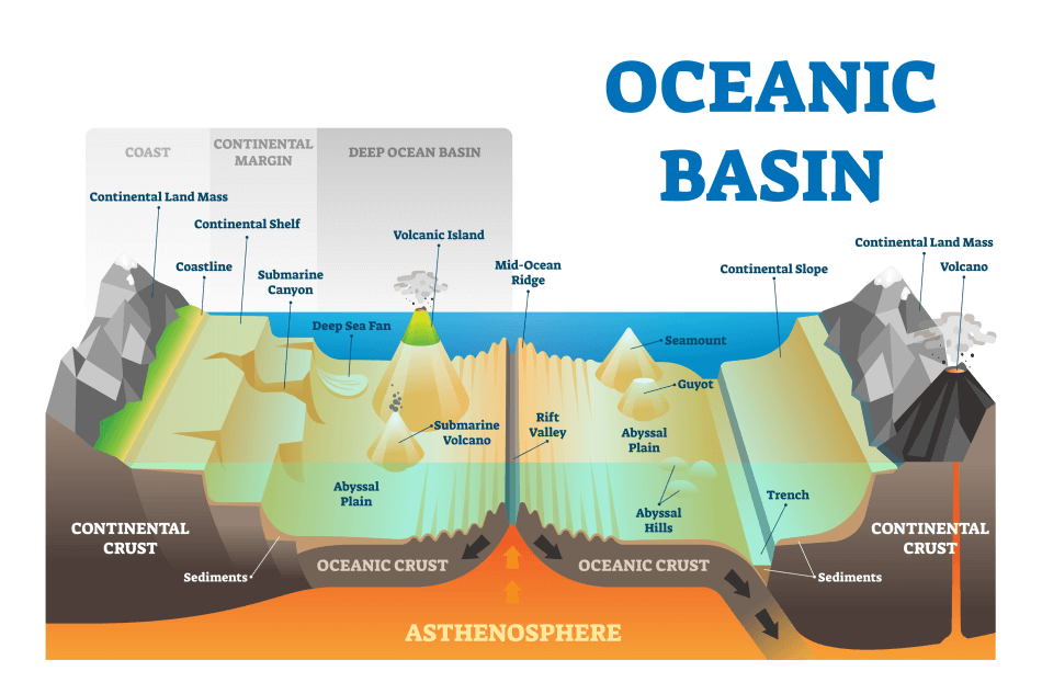
Continental margins consist of three parts, the continental shelf, slope, and rise. The continental shelves are areas that were dry land during the last ice age when sea levels were much lower than they are presently. Rising sea levels have flooded these areas which form a gentle slope to a depth of around 200 meters. Continental slopes are more steeply descending sections which then merge into shallower continental rises before ending at the abyssal plains. On average the distance from the start of the continental shelf to the abyssal plain is around 500 miles. The slopes of continental margins usually have rich deposits of oil and gas.
Continental slopes often have deep v-shaped valleys eroded into them due to the flow of rivers into the sea. As the courses of rivers change over time so does the major flow creating a series of valleys along the slope. Once formed these valleys continue to erode both due to currents and periodic underwater avalanches triggered by earthquakes or floods. The sediment which passes down these submarine canyons eventually comes to rest on the abyssal plain in a wide fan shape which can sometimes spread out for hundreds of miles and which contain rich nutrients.
The deepest sections of the abyssal plains are located around 500 miles off the continental shelves and plate margins. Most of the abyssal plains are covered with thick layers of sediment which are sometimes over 3 miles thick. Closer to the continental margins most of this sediment is gravel, sand, and mud. Further out to sea it is made up of a combination of sand and dust blown by winds and the remains of trillions of microscopic organisms which sink to the abyssal plain when they die. In some places these sediment deposits are over 100 million years old.
Polar Oceans
Polar oceans are distinguished from other oceans by the large amounts of ice which float on them in different forms. This ice is hugely important to the Earth’s climate as it insulates large areas of water from heating up during the summer and prevents the loss of heat in winter.
Ice shelves are the extensions of ice sheets and glaciers over water. Two of the largest, the Ross and Ronne-Filchner ice shelves, are located around the coasts of Antarctica. At their leading edges the sheets can have cliffs up to 60 meters high and extend almost 1000 meters underwater. Ice sheets gain ice from glaciers flowing into them, from snow falling onto them, and from sea water freezing under them. When sea ice freezes to the ice shelve it loses its salt creating a layer off cold, salty, dense water which sinks and flows away into deeper water. During the 20th and early 21st centuries large areas of ice sheet have broken up creating the risk of increased melting and sea-level rise.
Pieces of ice which have broken off from ice shelves are known as icebergs when they reach the open sea. These icebergs range in size from hundreds of square miles in area (known as tabular icebergs), to ones the size of ships (called bergy bits) and car-sized ones called growlers. Most icebergs in the north originate from Greenland and islands in the Canadian arctic. In the south they originate from the ice shelves around Antarctica. Most of these bergs drift close to their point of origin however some escape into the open ocean where they can occasionally cause danger to ships. Because icebergs are made of fresh water they have a lower density than the surrounding saltwater. Around 13% of an iceberg is able to float above the surface while the remaining 87% is underwater. In 1912 a large iceberg was responsible for the sinking of the ship Titanic as it sliced a huge hole in the hull causing it to sink in just a few hours with the loss of over 1,500 lives.
Sea ice, seawater which has frozen, covers around 7% of the Earth’s oceans. Sea ice forms in several phases:
- As the ocean water begins to freeze, small ice crystals (3 to 4 mm long) called frazil form. When they do so they expel salt into the water allowing them to float to the surface.
- Frazil crystals accumulate and bond together into different forms of sheet ice.
- In calm waters frazil crystals form a smooth, thin ice called grease ice which then develops into a continuous, thin sheet of ice called nilas. Currents or winds can push this nilas around so that sheets can slide over and under each other.
- In rough waters the frazil crystals accumulate into slushy circular discs called pancake ice which have raised edges due to the pancakes continually bumping into each other. Eventually the pancakes cement together and form a single sheet of ice.
Once sea ice has formed into a large sheet it continues to grow throughout the winter. When temperature rise in the spring the ice begins to melt. If it is not thick enough it will melt completely. If enough ice has grown during the winter then it will not completely melt and will remain until the following winter when it becomes known as multiyear ice. Sometimes large cracks called ice leads appear which allow ships and marine mammals to navigate the surface. Fast currents or the upwelling of warm water can also lead to the creation of large open areas free of ice called polynya.
In recent years the permanent ice cap (also known as perennial ice) at the North Pole has been shrinking due to the effects of global warming. The amount of sea ice at the South Pole has also decreased. As this sea ice reflects a huge amount of the suns energy back into space, the loss of this ice may lead to further warming only accelerating future ice loss.
Famous Oceans
The Arctic Ocean
- Name: Arctic Ocean
- Average Depth: 3,953 feet (1204.87 meters)
- Total Surface Area: 14.06 million square kilometers (5,430,000 square miles)
- Coastline Length: 45,390 km (28,200 mi)
The Arctic ocean covers an area of 5.4 million square miles, making it the smallest of Earth’s oceans. Because around a third of the ocean is permanently covered in ice, it is relatively unexplored. The ocean is also in continuous darkness from November to February and in continuous light from May to August.
The Arctic ocean has a large depression at its center with an average depth of over 4,000 meters. This basin is divided by a long submarine ridge, the Lomonosov Ridge, which creates two sub-basins. The Amerasia Basin is on the side facing North America while the Eurasian Basin faces Europe and Asia.
Around the edges of the Arctic Ocean lie the continental shelves of North America and Eurasia. On these shelves lie a large number of islands many of which are linked by ice during winter months.
The permanent ice cap is primarily made up of compressed pack ice with a thickness of up to 10 meters. Strong currents are continually moving this ice causing the formation of cracks and open pools. However since the 1950s this ice cap has thinned by as much as 40%. The breaking off of large bodies of ice from the main ice sheet has also increased.
The Arctic ocean is home to a large variety of birds, fish, and mammals. Polar bears are born on land but spend most of their lives on the sea ice where they hunt seals and even some whale species. Polar bears often lie in wait at holes in the ice waiting for these mammals to surface for air. Walruses also make their homes in the Arctic where they survive by eating shrimp, crabs, and molluscs. To protect against the cold water they, like other marine mammals, have a thick layer of fat (also known as blubber). The Arctic is home to a large number of different whale species including Beluga, Bowhead, Narwhals, and Killer whales. Fish found in these waters include Atlantic Cod, Haddock, Mackerel, and Salmon. Recent changes in Earth’s climate pose a considerable threat to many of these animals which are in danger of losing their habitats.
The Atlantic Ocean
- Name: Atlantic Ocean
- Average Depth: 11,962 feet (3,646 meters)
- Total Surface Area: 106.5 million square kilometers (41,100,000 square miles)
- Coastline Length: 111,866 km (69,510 mi)
The Atlantic ocean covers an area of over 40 million square miles, making it the second largest of Earth’s oceans. The mid-Atlantic ridge mountain range runs from north to south along its entire length taking up almost a third of the Atlantic’s total area. Either side are large abyssal plains.
Several peaks on the mid-Atlantic ridge have broken the surface of the ocean to form islands including Iceland, the Azores, and Ascension Island. In other places volcanoes have risen from the sea floor creating islands such as Bermuda, Tristan de Cunha, and the Canary Islands.
The waters of the Atlantic move in two large gyres. In the North Atlantic the gyre moves in clockwise direction while in the South Atlantic it moves counter clockwise. There is also a deep water circulation as cold water sinks at the poles and moves towards the Equator. When these different currents meet in the South Atlantic a portion of this water is brought to the surface bringing rich nutrients with it.
Weather in the Northern Atlantic is dominated by westerly winds (winds blowing from the west to the east), changeable weather, and frequent storms. Near the Equator is a region known as the Doldrums, in which low pressure creates calm conditions with few strong winds. Just North and South of this region are areas of higher pressure with almost constant easterly winds. In spring and summer months hurricanes can form in the southern parts of the North Atlantic and head west and northwest.
Because it covers so large an area the Atlantic has a huge variety of wildlife. Most notable are Humpback Whales, Sea Lions, Atlantic Seals, Penguins, Dolphins, Stingrays, Swordfish, Octopi, Sharks, and Tuna. There are also deep sea creatures including giant squid, viperfish, and hagfish. Close to the coast large flocks of birds including Seagulls, Pelicans, and Albatross feed of shoals of smaller fish such as sardines.
The Indian Ocean
Name: Indian Ocean
Average Depth: 12,274 feet (3,741 meters)
Total Surface Area: 70,5 million square kilometers (27,240,000 square miles)
Coastline Length: 66,526 km (41,337 mi)
The Indian Ocean covers an area of over 27 million square miles, making it the third largest of Earth’s oceans. The ocean was formed around 120 million years ago following the break up of the ancient supercontinent of Gondwana. The ocean floor is dominated by a large mid-ocean ridge shaped like an upside-down Y. One arm runs towards southern Africa where it joins with the Mid-Atlantic ridge. The other runs to southern Australia where it joins the Pacific-Antarctic Ridge. New oceanic crust is continually being created at these ridges forcing Africa, Antarctica, and Australia further apart each year.
The continental shelf around the Indian ocean is relatively narrow at around 75 miles. In some places it is scarred by deep canyons formed by the outflows of the Ganges, Indus, and Zambezi rivers. These rivers have also deposited large amounts of sediment onto the ocean’s abyssal plains.
The northern Indian ocean has a monsoon climate. Rain-bearing winds change direction twice a year creating alternative periods of drought and heavy rainfall in many surrounding regions. The warm waters of the Indian ocean are also responsible for the creation of tropical storms which head to the west. To the south of the monsoon zone lies a region of steady southeasterly winds which blow throughout the year. The southern part of the Indian ocean has light variable winds.
The warm conditions of the Indian ocean provide a rich environment for wildlife. Over 4,000 different species of fish live along coastal areas with many other species inhabiting areas of open and deep water. Most islands in tropical areas have surrounding coral reefs. Reefs can also be found off the western coasts of Thailand, Burma, and Eastern Africa.
Among the notable creatures of the Indian Ocean are Sea Cows, Hammerhead Sharks, Dolphins, Whale Sharks, Clown Fish, Manta Rays, Sea Snakes, Macaroni Penguins, Great White Sharks, Blue Whales, and Green Turtles.
The Pacific Ocean
Name: Pacific Ocean
Average Depth: 14,040 feet (4,280 meters)
Total Surface Area: 155 million square kilometers (60 million square miles)
Coastline Length: 15,500 km (9,600 miles)
The Pacific Ocean covers and area of over 60 million square miles making it the largest ocean on Earth. The rim of the Pacific ocean is dominated by a series of volcanic features and trenches, giving it the nickname of the “Ring of Fire”. The region is highly vulnerable to seismic activity and the accompanying risk of tsunami waves which can travel thousands of miles across the ocean before striking land.
Around three-quarters of the Pacific ocean lies over a single plate, the Pacific Plate. The southeastern Pacific is dominated by a large mid-ocean ridge known as the East Pacific Rise. The continental shelf on the west coasts of North and South America is narrow while on the east coasts of Asia and Australia the continental shelf is more irregular with many islands rising out of the sea. The western Pacific is also home to the deepest point on earth, the Challenger Deep in the Mariana Trench.
The waters of the Pacific move in two large gyres turning clockwise in the northern hemisphere and counter clockwise in the southern hemisphere. There is also a deep water circulation which reaches as far north as Japan before moving east across to North America.
The main winds of the Pacific are twin belts of westerly winds which blow either side of the Equator. The western Pacific is often badly affected by Typhoons which are generated in the late summer and early fall and which frequently hit the east Asian coast.
The Pacific has a huge variety of wildlife due to its range of environmental conditions. Species in cooler areas include Sea Otters, White Sided Dolphin, Sea Nettle Jellyfish, Dogfish, Tuna, Gray Whales, and Killer Whales. In tropical areas species include Triggerfish, Angelfish, Sea Serpents, Giant Kingfish, Silky Shark, Swordfish, Sunfish, Turtles, and Crabs.
The Southern Ocean (Antarctic Ocean)
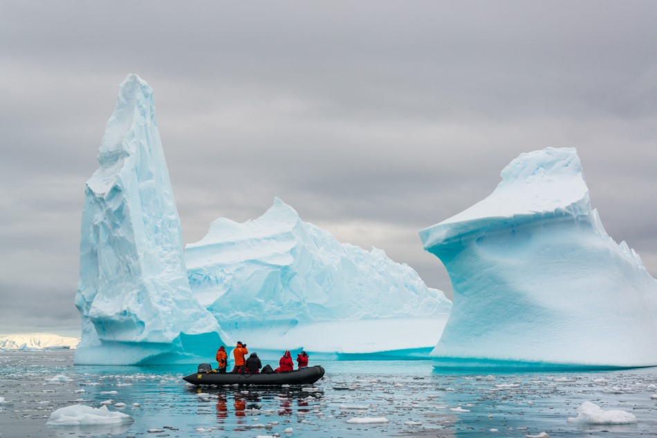
Name: Southern Ocean, also known as Antarctic Ocean
Average Depth: 10,728 feet (3,270 meters)
Total Surface Area: 21,960,000 square kilometers (8,479,000 square miles)
Coastline Length: 17,968 km. (11,165 miles)
The Southern Ocean covers an area of 8.4 million square miles, making it the second smallest of Earth’s oceans. For most of its area the ocean is deep at between four and five thousand meters. A series of basins are separated by underwater ridges. Its continental shelf is much deeper than most other parts of the world due to the massive amount of ice pushing down on the continent of Antarctica.
Currents flowing in the Southern Ocean are complex. Close to Antarctica the freezing of seawater to create ice shelves results in the expulsion of large amounts of salt. The cold salty water sinks and moves north at depth. This movement causes a constant upwelling bringing nutrient-rich waters to the surface. In winter large sections of the Southern Ocean freeze with the overall area of sea ice increasing seven or eight times.
As there is no land to slow them down, the Southern Ocean has the strongest currents and winds in the world. Huge waves have been known to strike and sink large ships with little warning..
The upwelling of nutrient rich waters provides abundant food. The basis of the food chain in the Southern Ocean is krill, a small crustacean which eats phytoplankton and algae. In turn krill provide food for fish, whales, seals, and birds.
Among the notable animals living in the Southern Ocean are Orca, Weddell Seals, Emperor Penguin, Blue Whales, Squids, Fur Seals, Wandering Albatross, Mackerel, Ice Fish, Toothfish, Sealions, Warty Squid, Sea Cucumber, and Starfish.
Ocean FAQs
What is the scariest fact about the ocean?
More than eighty percent of the ocean is still unexplored. Who knows what creatures are lurking in the deep dark depths.
What is the rarest sea creature?
The Vaquita is considered to be the rarest create in the world. It’s a small porpoise (similar to a whale or dolhpin), and is on the edge of extinction.
What is the deepest part of the ocean?
The deepest part of the ocean is called Challenger Deep, beneath the western Pacific Ocean. Challenger Deep is around 10,900 meters deep (35,800 feet), and is a relatively small slot type shape in the seabed.
How deep have we gone in the ocean?
The deepest ever dive was in the Mariana Trench, where a retired naval officer dove to nearly 36,000 ft. Victor Vescovo holds the Guinness World Record for the deepest dive by a crewed vessel.
What’s the biggest creature in the ocean?
To our knowledge, the Antarctic Blue Whale is the largest animal on the planet, and can weigh up to 400,000 pounds, which is the equivalent of 33 elephants. However, over 80% of the ocean is still unexplored, and larger creatures could be lurking in the depths.
What is the largest ocean?
The Pacific Ocean covers and area of over 60 million square miles, making it the largest ocean on Earth.
What is the smallest ocean?
The Arctic ocean covers an area of 5.4 million square miles, making it the smallest of Earth’s oceans.